Difference between revisions of "Bwindi Impenetrable National Park"
| Line 77: | Line 77: | ||
|Bwindi Impenetrable National Park (321 km²) | |Bwindi Impenetrable National Park (321 km²) | ||
|Reconnaissance walk | |Reconnaissance walk | ||
| − | | | + | | |
|McNeilage et al. 2001 | |McNeilage et al. 2001 | ||
|Sweep method, with high density of reconnaissance trails covering the forest. | |Sweep method, with high density of reconnaissance trails covering the forest. | ||
| Line 90: | Line 90: | ||
|Bwindi Impenetrable National Park (321 km²) | |Bwindi Impenetrable National Park (321 km²) | ||
|Reconnaissance walk | |Reconnaissance walk | ||
| − | | | + | | |
|McNeilage et al. 2006 | |McNeilage et al. 2006 | ||
|Sweep method, with high density of reconnaissance trails covering the forest. | |Sweep method, with high density of reconnaissance trails covering the forest. | ||
| Line 116: | Line 116: | ||
|Bwindi-Sarambwe ecosystem | |Bwindi-Sarambwe ecosystem | ||
|Reconnaissance walk | |Reconnaissance walk | ||
| − | | | + | | |
|Hickey et al. 2018 | |Hickey et al. 2018 | ||
|Sweep method, with high density of reconnaissance trails covering the forest. | |Sweep method, with high density of reconnaissance trails covering the forest. | ||
| Line 369: | Line 369: | ||
= Exposure to climate change impacts = | = Exposure to climate change impacts = | ||
| − | As part of a study on the exposure of African great ape sites to climate change impacts, Kiribou et al. (2024) extracted climate data and data on projected extreme climate impact events for the site. Climatological characteristics were derived from observation-based climate data provided by the Inter-Sectoral Impact Model Intercomparison Project ([www.isimip.org | + | As part of a study on the exposure of African great ape sites to climate change impacts, Kiribou et al. (2024) extracted climate data and data on projected extreme climate impact events for the site. Climatological characteristics were derived from observation-based climate data provided by the Inter-Sectoral Impact Model Intercomparison Project ([ISIMIP www.isimip.org]). Parameters were calculated as the average across each 30-year period. |
For future projections, two Representative Concentration Pathways (RCP) were used. RCP 2.6 is a scenario with strong mitigation measures in which global temperatures would likely rise below 2°C. RCP 6.0 is a scenario with medium emissions in which global temperatures would likely rise up to 3°C by 2100. For the number of days with heavy precipitation events, the 98th percentile of all precipitation days (>1mm/d) was calculated for the 1979-2013 reference period as a threshold for a heavy precipitation event. Then, for each year, the number of days above that threshold was derived. The figures on temperature and precipitation anomaly show the deviation from the mean temperature and mean precipitation for the 1979-2013 reference period. The estimated exposure to future extreme climate impact events (crop failure, drought, river flood, wildfire, tropical cyclone, and heatwave) is based on a published dataset by Lange et al. 2020 derived from ISIMIP2b data. The same global climate models and RCPs as described above were used. Within each 30-year period, the number of years with an extreme event and the average proportion of the site affected were calculated (Kiribou et al. 2024). | For future projections, two Representative Concentration Pathways (RCP) were used. RCP 2.6 is a scenario with strong mitigation measures in which global temperatures would likely rise below 2°C. RCP 6.0 is a scenario with medium emissions in which global temperatures would likely rise up to 3°C by 2100. For the number of days with heavy precipitation events, the 98th percentile of all precipitation days (>1mm/d) was calculated for the 1979-2013 reference period as a threshold for a heavy precipitation event. Then, for each year, the number of days above that threshold was derived. The figures on temperature and precipitation anomaly show the deviation from the mean temperature and mean precipitation for the 1979-2013 reference period. The estimated exposure to future extreme climate impact events (crop failure, drought, river flood, wildfire, tropical cyclone, and heatwave) is based on a published dataset by Lange et al. 2020 derived from ISIMIP2b data. The same global climate models and RCPs as described above were used. Within each 30-year period, the number of years with an extreme event and the average proportion of the site affected were calculated (Kiribou et al. 2024). | ||
Revision as of 06:49, 2 July 2024
East Africa > Uganda > Bwindi Impenetrable National Park
Français | Português | Bahasa Indonesia | Melayu
Summary
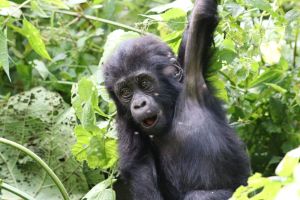
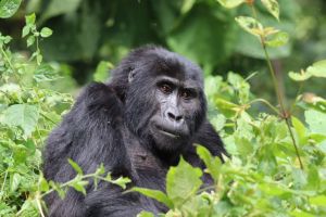
- Eastern chimpanzees (Pan troglodytes schweinfurthii) & Mountain gorillas (Gorilla beringei beringei) are present in Bwindi Impenetrable National Park.
- It has been estimated that 459 gorillas occur in the site; the chimpanzee population size is unknown.
- The gorilla population trend is increasing.
- The site has a total size of 321 km².
- Key threats to great apes are linked to high human presence, which poses some risk of disturbance and disease transmission.
- Conservation activities have focused on ecotourism programs and regularly monitoring the health of habituated gorillas.
- The park is a UNESCO Natural World Heritage Site.
Site characteristics
Bwindi Impenetrable National Park is located in southwestern Uganda, on the edge of the Albertine Rift Valley. The area is one of Uganda's oldest and most biologically diverse rainforests, which dates back over 25,000 years (Uganda Wildlife Authority). Encompassing a series of steep ridges and valleys, Bwindi is the source of five major rivers, which flow into Lake Edward. The park is famous for being home to almost half of the world's mountain gorilla population (Uganda Wildlife Authority). The site is a designated Important Bird Area, with 347 bird species documented in the forest, including 23 endemic species to the Albertine Rift (BirdLife International 2020). Bwindi was gazetted as a National Park in 1991 and declared a (UNESCO Natural World Heritage Site) in 1994.
Table 1. Basic site information for Bwindi Impenetrable National Park
| Species | Pan troglodytes schweinfurthii, Gorilla beringei beringei |
| Area | 321 km² |
| Coordinates | -1.017254, 29.671192 |
| Type of site | Protected area (National Park) |
| Governance type | Governance by government |
| Habitat type | Subtropical/tropical moist montane forest, subtropical/tropical moist lowland forest |
Types of sites ⋅ Governance types ⋅ Habitat types
Ape status
The park is home to one of the two subpopulations of mountain gorillas in the world, the Bwindi-Sarambwe subpopulation (Hickey et al. 2018). Increases in both the Virunga Massif and the Bwindi-Sarambwe subpopulations led to a change in the IUCN Red List classification from Critically Endangered to Endangered in 2018 (Hickey et al. 2018). In spite of this increase, the overall population size is still small.
Table 2. Ape population estimates in Bwindi Impenetrable National Park
| Species | Year | Occurrence | Encounter or visitation rate (nests/km; ind/day) | Density estimate [ind/ km²] (95% CI) | Abundance estimate (95% CI) | Survey area | Sampling method | Analytical framework | Source | Comments | A.P.E.S. database ID |
|---|---|---|---|---|---|---|---|---|---|---|---|
| Gorilla beringei beringei | 1997 | Present | 292 | Bwindi Impenetrable National Park (321 km²) | Reconnaissance walk | McNeilage et al. 2001 | Sweep method, with high density of reconnaissance trails covering the forest. | ||||
| Gorilla beringei beringei | 2002 | Present | 320 | Bwindi Impenetrable National Park (321 km²) | Reconnaissance walk | McNeilage et al. 2006 | Sweep method, with high density of reconnaissance trails covering the forest. | ||||
| Gorilla beringei beringei | 2011 | Present | 400 | Bwindi Impenetrable National Park (321 km²) | Genetic (dung/hair) | Roy et al. 2014 | |||||
| Gorilla beringei beringei | 2018 | Present | 459 | Bwindi-Sarambwe ecosystem | Reconnaissance walk | Hickey et al. 2018 | Sweep method, with high density of reconnaissance trails covering the forest. |
Sampling methods ⋅ Analytical frameworks
Threats
Table 3. Threats to apes in Bwindi Impenetrable National Park
| Category | Specific threats | Threat level | Description | Year of threat |
|---|---|---|---|---|
| 1. Residential & commercial development | Unknown | |||
| 2. Agriculture & aquaculture | Unknown | |||
| 3. Energy production & mining | Unknown | |||
| 4. Transportation & service corridors | Unknown | |||
| 5. Biological resource use | 5.1.2 Unintentional effects (species is not the target) | Low | Poaching as a non-target species; e.g., as a result of infant gorilla trafficking, snares are set up for other animals. Retaliatory killings are rare. Habituated gorillas are more vulnerable to poachers (Hickey et al. 2018). | Ongoing (2018) |
| 6. Human intrusion & disturbance | 6.3 Other human disturbances | Present (unknown severity) | Human presence due to tourism, conservation and scientific work, camps for security forces, etc., all of which pose some risk of disturbance and disease transmission (Hickey et al. 2018). | Ongoing (2018) |
| 7. Natural system modifications | Unknown | |||
| 8. Invasive & other problematic species, genes, diseases | 8.4 Pathogens | High | Vulnerability to human pathogens, and outbreaks of respiratory virus diseases and gastrointestinal parasite infections (Hickey et al. 2018). | Ongoing (2018) |
| 9. Pollution | Unknown | |||
| 10. Geological Events | Absent | |||
| 11. Climate change & severe weather | 11.1 Habitat shifting & alteration | Present (unknown severity) | Increased temperatures and modified rainfall patterns likely to cause changes in food availability and habitat quality (Hickey et al. 2018). | Ongoing (2018) |
| 12. Other options | Absent |
Conservation activities
The site is managed by the Uganda Wildlife Authority. The management of the site has developed ecotourism programs that support the livelihoods of local communities (UNESCO). Nine groups have been habituated for tourism; the first one was the Mubare gorilla group, since 1993. Conservation Through Public Health work on reducing human-gorilla conflicts in and around the park, and avoiding the transmission of diseases.
Table 4. Conservation activities in Bwindi Impenetrable National Park
| Category | Specific activity | Description | Implementing organization | Year of activity |
|---|---|---|---|---|
| 1. Development impact mitigation | Not reported | |||
| 2. Counter-wildlife crime | Not reported | |||
| 3. Species health | 3.11 Implement continuous health monitoring | The (Gorilla Doctors) who work at Bwindi Impenetrable National Park regularly monitor the health of habituated gorillas. | Ongoing (2024) | |
| 4. Education & awareness | Not reported | |||
| 5. Protection & restoration | 5.2 Legally protect ape habitat | The site was declared a National Park in 1991. | 1991-Ongoing (2024) | |
| 6. Species management | 6.1 Habituate primates to human presence to reduce stress from tourists/researchers | Ongoing (2024) | ||
| 7. Economic & other incentives | Not reported | |||
| 8. Permanent presence | 8.2 Run tourist projects and ensure permanent human presence at site | Ongoing (2024) |
Conservation implementation challenges and enablers
Table 5. Challenges reported for Bwindi Impenetrable National Park
| Category | Challenge | Source | Year(s) |
|---|---|---|---|
| 1. Site management | Not reported | ||
| 2. Resources & capacity | Not reported | ||
| 3. Engaged community | Not reported | ||
| 4. Institutional support | Not reported | ||
| 5. Ecological context | Not reported | ||
| 6. Safety & stability | Not reported |
Table 6. Enablers reported for Bwindi Impenetrable National Park
| Category | Enabler | Source | Year(s) |
|---|---|---|---|
| 1. Site management | Not reported | ||
| 2. Resources & capacity | Not reported | ||
| 3. Engaged community | Not reported | ||
| 4. Institutional support | Not reported | ||
| 5. Ecological context | Not reported | ||
| 6. Safety & stability | Not reported |
Research activities
Documented behaviours
Table 7. Ape behaviors reported for Bwindi Impenetrable National Park
| Behavior | Source |
|---|---|
| Not reported |
Exposure to climate change impacts
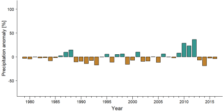
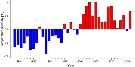
As part of a study on the exposure of African great ape sites to climate change impacts, Kiribou et al. (2024) extracted climate data and data on projected extreme climate impact events for the site. Climatological characteristics were derived from observation-based climate data provided by the Inter-Sectoral Impact Model Intercomparison Project ([ISIMIP www.isimip.org]). Parameters were calculated as the average across each 30-year period. For future projections, two Representative Concentration Pathways (RCP) were used. RCP 2.6 is a scenario with strong mitigation measures in which global temperatures would likely rise below 2°C. RCP 6.0 is a scenario with medium emissions in which global temperatures would likely rise up to 3°C by 2100. For the number of days with heavy precipitation events, the 98th percentile of all precipitation days (>1mm/d) was calculated for the 1979-2013 reference period as a threshold for a heavy precipitation event. Then, for each year, the number of days above that threshold was derived. The figures on temperature and precipitation anomaly show the deviation from the mean temperature and mean precipitation for the 1979-2013 reference period. The estimated exposure to future extreme climate impact events (crop failure, drought, river flood, wildfire, tropical cyclone, and heatwave) is based on a published dataset by Lange et al. 2020 derived from ISIMIP2b data. The same global climate models and RCPs as described above were used. Within each 30-year period, the number of years with an extreme event and the average proportion of the site affected were calculated (Kiribou et al. 2024).
Table 8. Estimated past and projected climatological characteristics in Bwindi Impenetrable National Park
| 1981-2010 | 2021-2050, RCP 2.6 | 2021-2050, RCP 6.0 | 2071-2099, RCP 2.6 | 2071-2099, RCP 6.0 | |
| Mean temperature [°C] | 16.6 | 17.8 | 17.5 | 17.9 | 19.1 |
| Annual precipitation [mm] | 1272 | 1288 | 1422 | 1293 | 1411 |
| Max no. consecutive dry days (per year) | 19.4 | 28.4 | 28.9 | 31.6 | 25.8 |
| No. days with heavy precipitation (per year) | 5.6 | 6.9 | 8.1 | 7.5 | 9.5 |
Table 9. Projected exposure of apes to extreme climate impact events in Bwindi Impenetrable National Park
| No. of years with event (2021-2050, RCP 2.6) | % of site exposed (2021-2050, RCP 2.6) | No. of years with event (2021-2050, RCP 6.0) | % of site exposed (2021-2050, RCP 6.0) | No. of years with event (2070-2099, RCP 2.6) | % of site exposed (2070-2099, RCP 2.6) | No. of years with event (2070-2099, RCP 6.0) | % of site exposed (2070-2099, RCP 6.0) | |
| Crop failure | 5 | 0.28 | 4 | 0.72 | 5.5 | 0.38 | 6 | 0.18 |
| Drought | 0 | 0 | 0 | 0 | 0 | 0 | 0 | 0 |
| Heatwave | 0 | 0 | 0 | 0 | 0 | 0 | 0 | 0 |
| River flood | 1 | 1.98 | 3 | 2.77 | 1.5 | 1.74 | 3.5 | 2.88 |
| Tropical cyclone | 0 | 0 | 0 | 0 | 0 | 0 | 0 | 0 |
| Wildfire | 30 | 1.11 | 30 | 0.88 | 29 | 1.13 | 29 | 0.75 |
External links
UNESCO Bwindi Impenetrable National Park
Uganda Wildlife Authority
Bwindi Forest National Park in Uganda
References
BirdLife International. (2020). Important Bird Areas factsheet: Bwindi Impenetrable National Park. Downloaded from http://www.birdlife.org on 30/12/2020.
Hickey, J.R., Basabose, A., Gilardi, K.V., Greer, D., Nampindo, S., Robbins, M.M. & Stoinski, T.S. (2018). Gorilla beringei ssp. beringei. The IUCN Red List of Threatened Species 2018: e.T39999A17989719. http://dx.doi.org/10.2305/IUCN.UK.2018-2.RLTS.T39999A17989719.en
Roy, J., Vigilant, L., Gray, M., Wright, E., Kato, R., Kabano, P., Basabose, A., Tibenda, E., Kühl, H.S. and Robbins, M.M. (2014). Challenges in the use of genetic mark-recapture to estimate the population size of Bwindi mountain gorillas (Gorilla beringei beringei). Biological Conservation 180: 249–261
McNeilage, A., Plumptre, A. J., Brock-Doyle, A., & Vedder, A. (2001). Bwindi Impenetrable National Park, Uganda: Gorilla census 1997. Oryx, 35(1), 39-47. https://doi.org/10.1046/j.1365-3008.2001.00154.x
McNeilage, A., Robbins, M. M., Gray, M., Olupot, W., Babaasa, D., Bitariho, R., Kasangaki, A., Rainer, H., Asuma, S., Mugiri, G., & Baker, J. (2006). Census of the mountain gorilla Gorilla beringei beringei population in Bwindi Impenetrable National Park, Uganda. Oryx, 40(4), 419-427. https://doi.org/10.1017/S0030605306001311
Kiribou, R., Tehoda, P., Chukwu, O., Bempah, G., Kühl, H. S., Ferreira, J., ... & Heinicke, S. (2024). Exposure of African ape sites to climate change impacts. PLOS Climate, 3(2), e0000345.
Lange, S., Volkholz, J., Geiger, T., Zhao, F., Vega, I., Veldkamp, T., ... & Frieler, K. (2020). Projecting exposure to extreme climate impact events across six event categories and three spatial scales. Earth's Future, 8(12), e2020EF001616.
Page completed by: A.P.E.S. Wiki team Date: 14/01/2021


